Agriculture & Farm Management
Track farming teams on the field, assign crop activities, and monitor progress using a clear dashboard designed as a reliable GPS powered agriculture CRM for modern farm operations.
Track farming teams on the field, assign crop activities, and monitor progress using a clear dashboard designed as a reliable GPS powered agriculture CRM for modern farm operations.
Large and scattered farms create challenges such as delayed communication, unclear task progress, and missing maintenance records. Without GPS-based tracking, supervisors often rely on guesswork instead of clear information.
A complete GPS-powered agriculture CRM that brings clarity to your farm operations
Designed for modern farming to helps track fields, manage operations, and share accurate locations even in remote areas with poor connectivity.
Create farms, add machinery checkpoints, and set up inspection points with GPS coordinates and detailed instructions.
Monitor field workers, crop supervisors, and inspection teams on an interactive map with location history.
Assign soil testing, irrigation checks, crop spraying, planting, harvesting, or equipment maintenance with clear protocols.
Every field activity includes GPS-verified timestamps to confirm when and where work was completed.
Capture soil photos, crop health images, pest sightings, and equipment conditions directly from mobile devices.
View completed tasks, pending checks, and daily team activity in an organized, searchable timeline.
Transform your farm operations with measurable improvements.
Whether you manage crops, livestock, or specialty farming, our system adapts to your needs.
Farmers manage every plot with clear names, mapped borders, and accurate field sizes. Boundaries stay consistent each season, cutting extra trips and wasted work. Obstacles are marked once and stored safely, keeping machines protected and crops undamaged. All data stays digital, easy to export, and ready whenever audits or buyers need proof.
Multiple Field Management:
All plots saved with clear names, size, and last work done. Operators can quickly pick the right field without calling the owner again. It reduces confusion with rotating staff.
Field Boundary Confidence:
Mapped borders stay accurate for the next visit, cutting time wasted driving edges again. Fewer mistakes with spray and seed use.
Accurate Polygon Mapping:
Correct area helps calculate seed and fertilizer better. Farmers avoid overspending on inputs and show clear records to buyers.
Season-to-Season Reuse:
No need to redraw borders at the start of every crop cycle. Teams can start work right away with saved maps.
Obstacle Marking:
Rocks, poles, wet spots, and trees marked once so machines steer clear every time. Less crop damage and safer driving.
Clean Data Storage:
Field info stored digitally instead of scattered on paper or local devices. Easier for everyone to find the right data.
Audit-Ready Files:
Field data exports fast when required by regulators or buyers. Less stress during inspection days.
Dairy teams keep paddocks and feed fields labeled clearly, making feed planning simple and steady. Workers can see past activity, follow accurate routes, and avoid mistakes with manure placement thanks to GPS logs. Boundaries update fast when land changes, and clean maps make audits smoother with far less stress.
Feed Field Tracking:
Every acre for silage and fodder labeled and saved. Helps plan feed supply for cows without guessing.
Paddock History:
Shows when a field was last cut, sprayed, or seeded. Work planning becomes easier and more steady.
Manure Placement Proof:
GPS logs show safe spreading away from ponds and wells. Good records support soil health rules.
Lease Flexibility:
Boundaries updated easily when land shifts. No lost knowledge when agreements change.
Smooth Routing:
Workers travel directly to the right paddock, saving fuel and time. New staff settle faster.
Compliance Support:
Organized maps help during dairy program audits. Less paperwork and backtracking.
Small plots mapped clearly, helping teams avoid mix-ups with chemicals, water lines, or crop blocks. Workers can follow straight paths with less damage to plants, making daily tasks feel smoother. Shared maps keep everyone aligned, and clean traceability records give buyers more confidence in the harvest.
Precise Mapping for Small Plots:
Good for narrow rows and mixed crops. Helps avoid wrong chemical amounts and crop stress.
Row & Bed Accuracy:
Straight lines guide tractors and workers safely. Reduced bruising or plant breaks during operations.
Water and Spray Control: Clear marking of drip lines and blocks avoids overuse and missed areas. Supports healthy harvests.
Multiple Harvest Cycles:
Every cycle tracked on map so inputs and labor can be managed better.
Team Sharing:
One set of maps shared to all devices. Cuts mistakes caused by guessing field positions.
Traceability:
Buyers and food safety groups get reliable field origin records. Builds more trust in produce quality.
Manage manure use, feed plots, and hygiene zones with clear GPS records that stay tidy and easy to check. Staff reach the right fields faster, follow clean routes, and avoid risk areas, making daily work smoother. Feed sources stay tracked season after season, helping control costs while keeping biosecurity strong.
Nutrient Planning:
Manure spread fields stored with GPS logs. Helps prove balanced use across seasons.
Zone Control:
GPS zoning around sheds for staff and vehicle paths supports better hygiene rules.
Feed Source Tracking:
Fields used for feed tracked to measure supply and cost. Helps reduce purchases from outside.
Simple Field Access:
Staff can reach feed plots faster with saved directions. Less fuel, less time lost.
Cleaner Vehicle Routes:
Defined entry and exits help avoid biosecurity risk areas. Better control in daily operations.
Support areas mapped clearly, helping teams manage soil, compost, and space planning without guesswork slowing them down. Pipes, pumps, and fences stay marked for easy repairs, letting workers fix things quicker and with less wandering around. Clean maps also support audits and guide new staff to the right spots, making daily work smoother and more organized.
Support Field Overview:
Outside cropping areas mapped to manage soil and compost sources efficiently. Keeps supply stable.
Utility Layout:
Pipes, pumps, and fence lines marked once and saved. Workers fix issues faster with less searching.
Certification Help:
Clean GPS maps support audits for quality and safety. Cuts paperwork stress.
Space Planning:
Exact borders guide future expansion plans with clarity. Reduces mistakes in structure placement.
Staff Direction:
Clear guidance to work spots outside buildings helps new staff keep pace.
Keep every plot labeled clearly, helping managers give tasks without mix-ups slowing things down. Operators pick the right field on the first try, and updates stay shared so no one uses old maps by accident. One clean set of records also builds trust with buyers during large supply deals.
Central Library:
All scattered plots organized and labeled. Managers avoid mix-ups when giving tasks.
Operator Accuracy:
Right field selected on first try, even with seasonal or new workers. On-site delays drop.
Fast Updates:
Plot changes saved instantly, so everyone stays aligned. No outdated maps used by mistake.
Team Sync:
One trusted version of field data accessed by all members. Better flow in daily work.
Buyer Trust:
Clear records create confidence when fulfilling large supply deals.
This CRM gives managers a clear view of work happening across many fields, making remote supervision feel simple and steady. Costs and machine movement become easier to review, helping teams cut waste and plan smarter. Clean maps and tidy logs also support reports and traceability, building confidence in every contract.
Large-Scale Oversight:
Managers check progress and machine activity across many farms. Remote control becomes easier.
Cost Review:
Field logs tied to area help track spending on each unit. Supports stronger financial decisions.
Machine Use Efficiency:
Better routing means less idle movement and fuel. Improves return on machinery.
Manager Reports:
Field data shown in simple views for meetings. Saves hours making manual summaries.
Strong Data Chain:
Accurate maps support traceability and contract performance.
Crews can start jobs fast by loading client fields in minutes, letting teams finish more work in a day. Straight paths and clear maps improve results, making customers happy while cutting fuel from repeated passes. Clean records attach to bills for quick payments, and saved maps make return visits easy with no setup stress.
Quick Job Setup:
Load client’s field and begin work in minutes. More jobs done per day.
Straight lines reduce mistakes and boost customer satisfaction. They see clean results.
Work Proof:
Maps attach to invoices with time and area worked. Faster payment and fewer disputes.
Reduced Fuel:
Fewer re-runs and corrections cut fuel cost. Helps win more profit from each job.
Repeat Clients:
Return next season with all maps ready. Shows reliability and saves setup time.
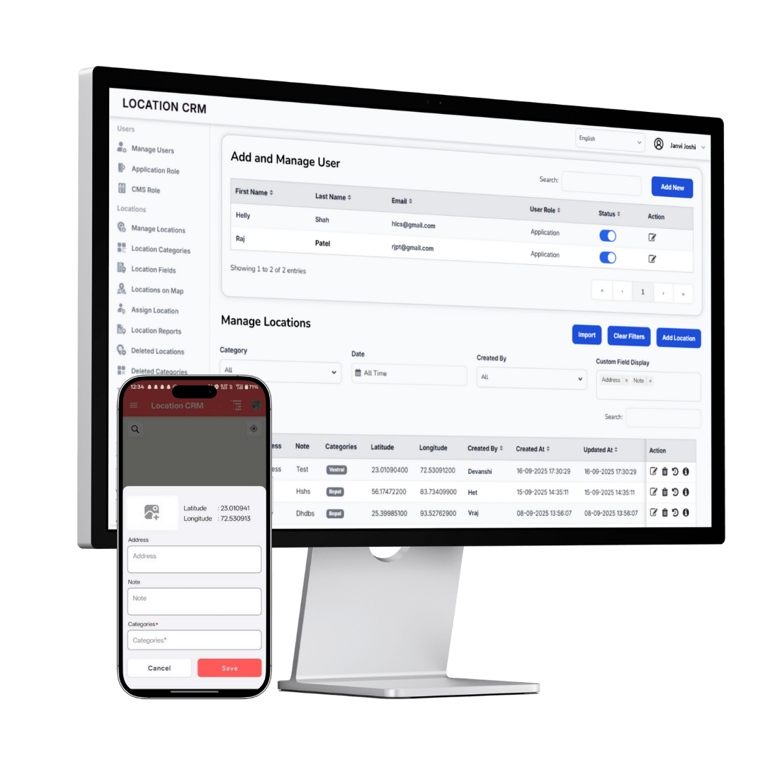
With a simple setup, you can organize your farmland, give work to the right team members, and review their updates in one place. Notes and photos help you follow their progress with ease.
Add staff members, define farmland sections, and create crop task templates.
Allocate planting, spraying, inspection, harvesting, or irrigation work to field teams.
Access notes, photos, logs, and performance reports for data-driven decisions.
Improve field coordination, reduce delays, and manage your entire farm with a simple location-based system powered by a reliable Map based agriculture CRM.
Yes, the platform supports unlimited field locations. Add and organize as many farms, plots, and checkpoints as you need through our GPS-powered location system.
Absolutely. Workers can upload photos, add notes, and update progress directly from their mobile phones while in the field.
Yes, create custom roles like admin, supervisor, and field staff with specific permissions for each role.
Yes, each inspection visit includes time-stamped logs, photos, notes, and GPS verification for complete accountability.
Yes, our system scales perfectly from small family farms to large multi-plot agricultural enterprises.